In July, I went to Zakopane, Poland, for a hiking holiday. It’s one of my absolute favourite places in the world, and the mountains are stunning. I already posted about my hikes to Kasprowy Wierch and to Czerwone Wierchy. Today, I’m going to take you to Karb – a spot I didn’t know about until the day I went there, partly by accident. It’s not a well known trail, but it’s actually phenomenal and I can recommend it if you’re visiting Tatra Mountains.
Getting to the start of the trail
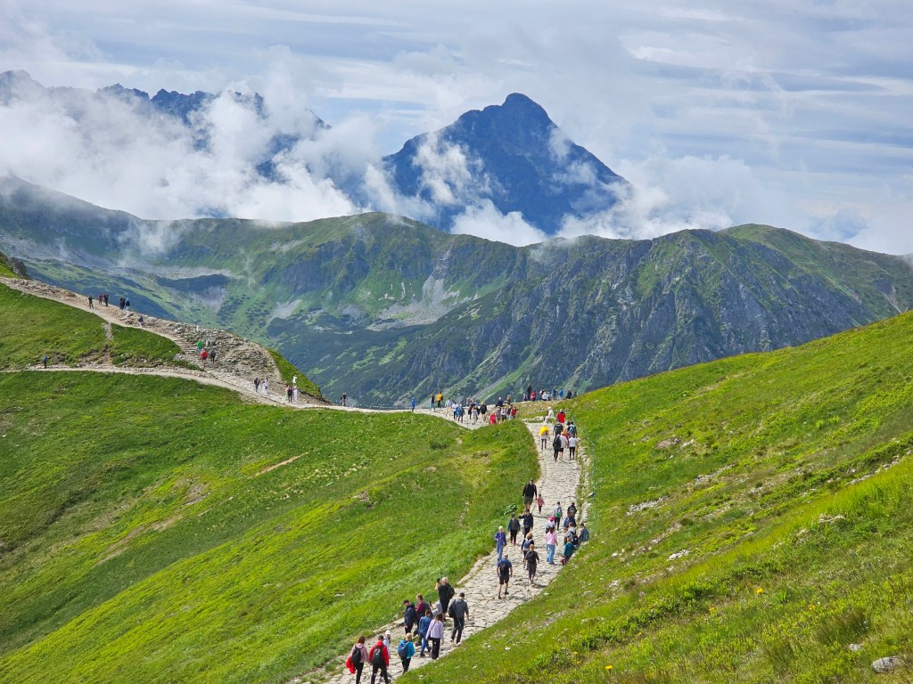
We started our journey in Kuznice, where we got from the centre of Zakopane on a bus. You can drive to Kuznice too, there are some car parks in the area – however, it’s probably cheaper to take a bus if you can. From the bus stop, we walked a couple of minutes to the entrance of the national park where we bought our tickets. That’s when the hike officially started.
From Kuznice to Murowaniec
If you’ve read about our hike to Kasprowy Wierch, the beginning of today’s journey might sound familiar to you. And rightly so! Our route led us via Murowaniec shelter, where we got following the blue trail from Kuznice. The reason why we decided to repeat a route we’d taken a couple of days before was that it heavily rained for 48 hours, and a lot of other trails in Tatra Mountains were flooded and inaccessible. We didn’t want to completely give up hiking that day – we had already lost two days of our holiday due to bad weather, and we were desperate to start hiking again. We didn’t know what state the trail was in, but it seemed like a safe choice given the situation – there are no rivers along that trail, which is rare in Tatra Mountains. Most of the trails on the Polish side of the mountains start in valleys that have streams running alongside.
Our plan for the day was to get to the start of the trail, assess the conditions, and then improvise. The official information from the national park’s authorities was that many trails were flooded and hiking was discouraged. And naturally, safety first! We were prepared to abandon our hike if the conditions on the trail were unsafe.
Luckily, we got to Murowaniec without any issues, it took us under 2 hours. There was a little bit of mud in some parts of the trail, but that’s about it. If we hadn’t known that it had poured down for two days straight, we wouldn’t have guessed.
From Murowaniec to Czarny Staw Gasienicowy – beautiful lake
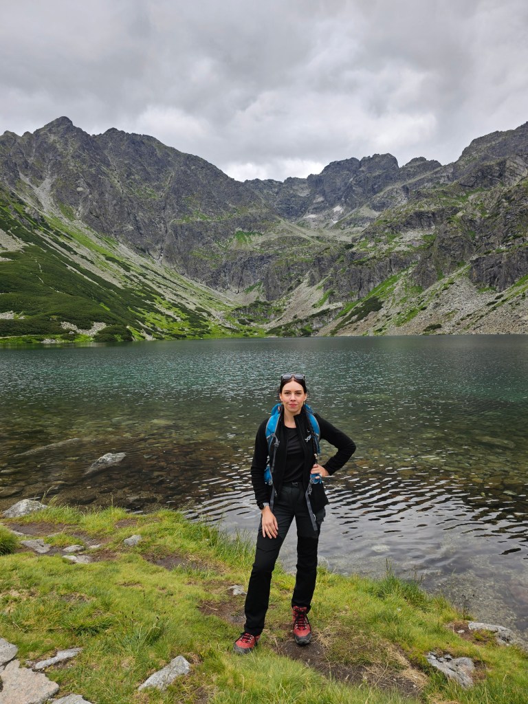
Since the conditions weren’t bad, we decided to continue our hike. There are a few routes starting from Murowaniec. We discarded the one to Kasprowy Wierch, since we had already climbed it a few days before. We also eliminated the trail to Swinica, as it’s a challenging mountain and hiking in rough terrain was strongly discouraged by the authorities. So, we decided to head to Czarny Staw Gasienicowy – a stunning lake, located at the foot of some of the highest and most challenging peaks of Polish mountains.
I don’t think I had been to that lake before, despite numerous holidays in Tatra Mountains. There just never was the right time for it, until this year.
The lake is beautiful, and I highly recommend visiting it if you have a chance. It took us around 30 minutes to get there from Murowaniec, and it was a fun, relatively easy, and largely flat route. Czarny Staw Gasienicowy isn’t as large as Morskie Oko – the most famous lake in Polish mountains – but it’s still stunning.


Failed attempt to get to Zadni Granat
The day was young and we were still full of energy, so we decided to keep going. We wanted to follow the trail to Zadni Granat – more specifically, the easiest possible route to Zadni Granat. There are several trails running in that direction, but some of them are considered challenging and potentially dangerous – certainly not suitable for bad weather.
Unfortunately, our plans had to change after less than 5 minutes. In order to get to Zadni Granat from Czarny Staw Gasienicowy, one has to follow the path around the lake. Sadly, the path was flooded following the recent rainfall, and there was no way around it. We didn’t fancy getting our feet wet in cold weather, and it likely would have been dangerous anyway. So, we headed back to where the trails forked, and chose to go in the opposite direction.

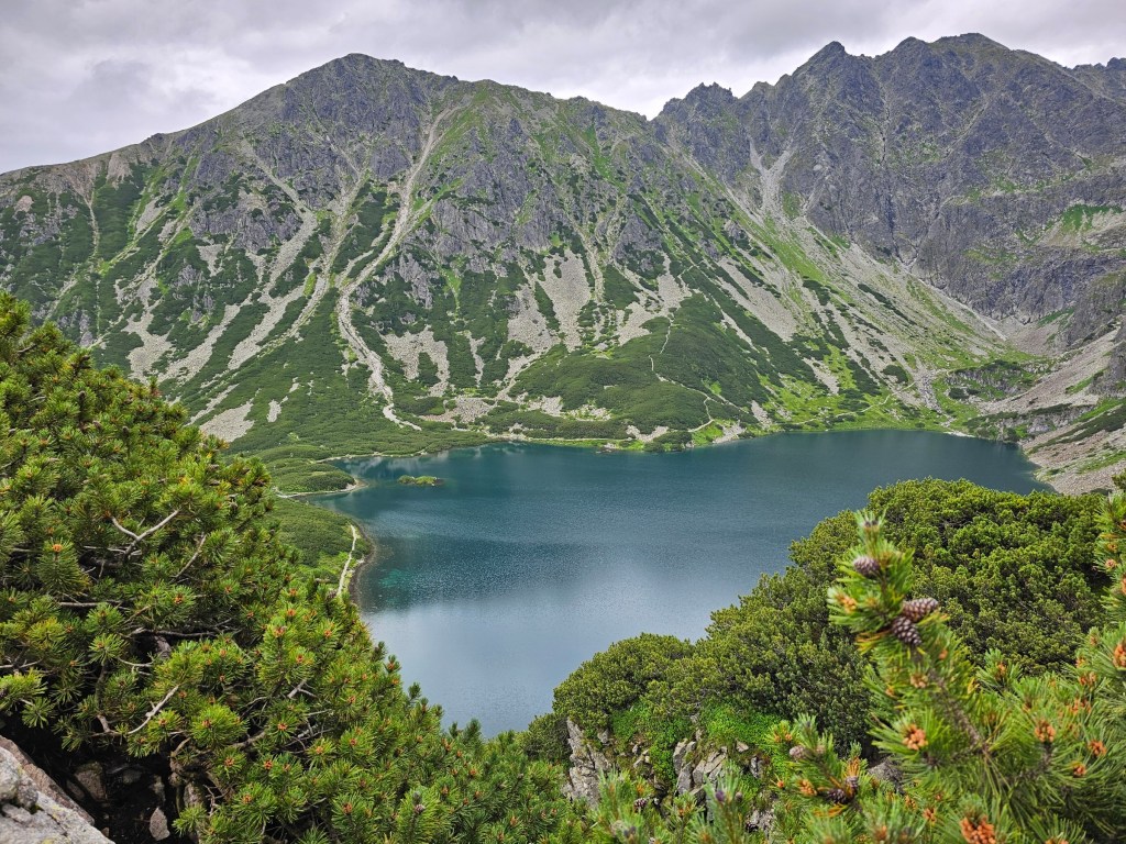
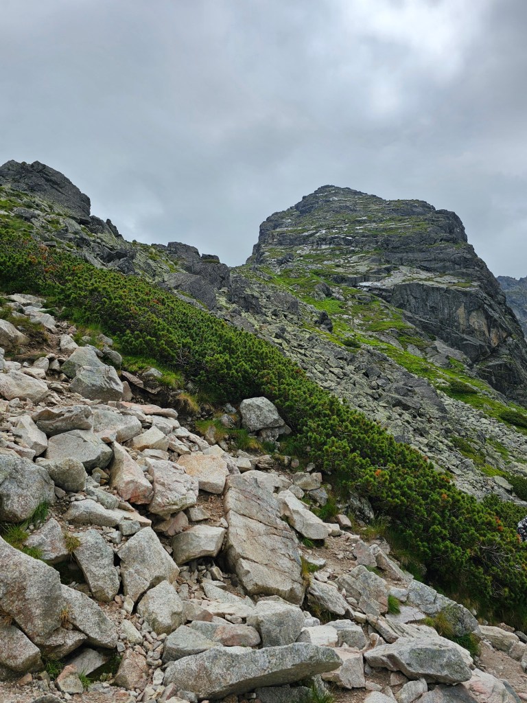
A climb to Karb
We saw a black trail starting at Czarny Staw Gasienicowy, and we could see people walking uphill. We had never heard of that trail before, but – after confirming online that it wasn’t one of the challenging and potentially highly dangerous routes, we decided to give it a go. Worst case scenario, we said, we could always turn back.
We actually loved that ascent. It was quite steep, and there were a few places with lots of exposure, but it didn’t feel dangerous. We just had to pay attention to the route and be careful – both of which are useful even on the easiest of hikes.
After about 30 minutes, we got to Karb, 1853 metres high. That’s when we discovered that it was less than an hour away from the peak of Koscielec – one of the peaks considered to be advanced and challenging. We didn’t think it was a good idea to go there without prior research and preparation, but it was great to see all the climbers conquering Koscielec. In fact, from Karb, you can pretty much see the entire route to the top of Koscielec. I’ve never been so close to a “challenging” peak in Tatra Mountains, and it certainly inspired me to climb it myself in the future – hopefully, on a day with much more favourable weather.


Descent from Karb to Hala Gasienicowa
We took a short break at Karb. We had a meal whilst enjoying the views. After that, it was time to descend.
We had two options. We could either go down the same way we climbed up – via the lake – or, alternatively, there was a blue trail running on the other side of the hill, down to Hala Gasienicowa where Murowaniec is. We chose the latter, as the route seemed less steep. I don’t mind large rocks and exposure when climbing up, but they can be quite tiring and dangerous on the way down. Plus, we simply wanted to see a new trail instead of going down the route we already knew.
So, we followed the blue trail to Hala Gasienicowa. The route was easy, certainly less steep than the black trail from Czarny Staw Gasienicowy to Karb. We did have to cross a small river at one point, walking on the rocks sticking out of the water. The path was flooded following the rains, but there was a way to get through the water without getting your feet wet. It was a bit scary, but we managed to get to the other side. There were quite a few people crossing the stream in both directions, so we made sure to watch and memorise the safe route. The flooded section was only about 5 metres wide, so it wasn’t too bad. Other than that, the descent from Karb to Hala Gasienicowa was easy.
The signs on that trail were a bit confusing. On top of Karb, a sign said that it would take us 50 minutes to get to Hala Gasienicowa. I don’t know which point of Hala Gasienicowa that referred to – it took us well over an hour to get to Murowaniec, which is technically located in Hala Gasienicowa too. And we walk quite fast!


Quick break at Murowaniec
We had a quick break at Murowaniec – we refuelled and bought some souvenirs. The shelter was very crowded. It’s generally a popular place, and I imagine the fact that many other trails were flooded meant that more people chose to visit the ‘safe’ option.
Back to Kuznice
From Murowaniec, we followed the blue trail to Kuznice. It took us about 1h 30 minutes to descend to civilisation. Then, once again, we took a bus to the centre of Zakopane.
Summary of the hike
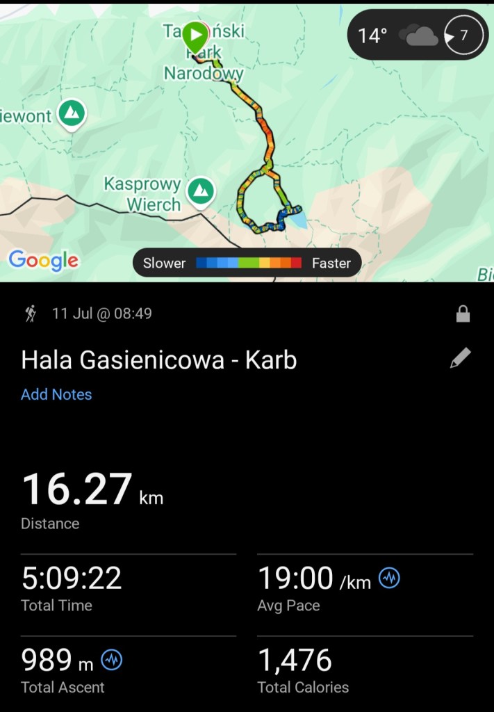
Overall, our hike was 16 kilometres long, with just under 1000 metres elevation gain. It took us 5 hours 10 minutes, excluding any breaks – I paused the tracking on my smartwatch during longer stops. It was a short hike for my standards, but I absolutely loved this route, especially the climb from Czarny Staw Gasienicowy to Karb. I quite enjoy steeper trails with a thrill of exposure and greater heights, and it was right up my street. We didn’t have a concrete plan for the day and we were prepared to have to abandon the hike early on in case of unsafe conditions and bad weather, so we were relieved to be able to actually do some hiking that day. I got to see parts of my beloved mountains that I hadn’t seen before, and I got inspired to one day return to conquer some of the more challenging peaks. Overall, it was a fantastic day!
Also see: