This year, I decided to spend my summer holiday in one of my all-time favourite places in the world – the beautiful Tatra Mountains in the south of Poland. I’ve hiked in those mountains many times in the past, but not in the last 10 years or so, and I was longing to go back. In today’s post, I’ll take you on a hike to the top of Kasprowy Wierch – one of the most popular peaks in Poland, with wonderful views.
Getting to the start of the trail
There are a few different ways of getting to the top of Kasprowy Wierch, but all of the direct trails start at the same location – Kuznice. You can drive to Kuznice (there are car parks in the area), or you can take a bus from the centre of Zakopane. If you can, I highly recommend choosing the bus. They get you right to the start of the trail and will likely end up being cheaper than paying for the car park.

Choosing your trail
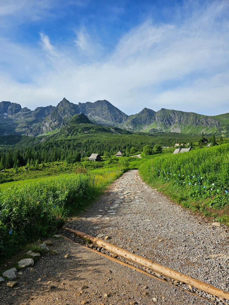
There are 3 different trails between Kuznice and Kasprowy Wierch, marked with blue, yellow, and green. The green trail goes directly to the top of Kasprowy Wierch, while the blue and yellow merge halfway through, and lead through Hala Gasienicowa, a popular, picturesque place in Tatra Mountains. There’s a hostel with a restaurant there, called Murowaniec – a great place for a quick break. All three routes between Kuznice and Kasprowy Wierch take a similar amount of time, around 3 hours. For that reason, I recommend choosing the trail offering the best views, which in my opinion is the blue one. That’s the one I chose.
Starting off
First things first – Tatra Mountains are a protected area, and you need to pay a small fee to enter the national park. A single adult ticket was 11 PLN in 2025 – around £2.
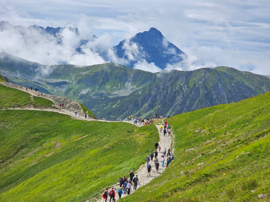
The blue and yellow trails run in parallel and merge after about an hour. The yellow trail starts off flat, to then lead uphill before the merge. The blue trail is the opposite – it starts off with an ascent right off the bat, to then reward you with a period of a nice, flat walk with beautiful views of the surrounding mountains. From there, you can see Giewont – by far the most famous peak in Poland, easily recognisable thanks to a large metal cross at the top. You can also see your destination, Kasprowy Wierch.


A break at Murowaniec
About 15 minutes after the blue and yellow trails’ merging point, you’ll enter Hala Gasienicowa – a beautiful, green area with a panoramic view of some of the country’s highest peaks, often covered with clouds. Continue walking along the blue trail and in a few minutes you’ll reach Murowaniec. We had a coffee/hot chocolate break there.
By the way – shelters in the Polish mountains usually have unique stamps. You can collect those in the official PTTK booklets, which you can buy in most of the shelters and at the national park’s entrance cash point. Naturally, we collected our stamps at Murowaniec. It’s the shelter’s 100 year anniversary in 2025 and they had a limited edition stamp available.

Ascent to Kasprowy Wierch
After our break at Murowaniec, we began the final stretch of the ascent. This time, we followed along the yellow trail to Kasprowy Wierch.
It’s quite a steep ascent, but you’re rewarded with wonderful views. You can see some of Hala Gasienicowa’s ponds as well as the rough peaks of some taller mountains. Throughout the whole ascent, you can see your destination too. There’s a building on top of Kasprowy Wierch, and it feels so, so close! It does, however, take about 1-1.5 hour to get there.

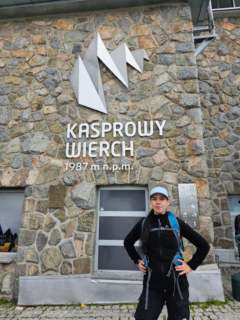
At the top of Kasprowy Wierch
After a tiring but enjoyable climb, we reached our destination – Kasprowy Wierch. It was quite crowded. After all, it’s one of the country’s most popular mountains. Partly because… there’s a cable car that can take you from Kuznice to the very top of Kasprowy Wierch. It’s somewhat pricey for Poland’s standards – a return adult ticket was around 160 PLN (£32). If you’d like to visit Kasprowy Wierch by cable car, it’s recommended to book the tickets in advance – you can buy them online.
We, however, prefer a hike and would never swap the 3 hour uphill walk for 20 minutes in a cable car. To each their own!
At the top of Kasprowy Wierch, in the same building as the cable car station, there’s a restaurant and a small souvenir shop. And of course, there’s a stamp too! This one was hidden in a nook opposite the souvenir shop.
By the way, the actual peak of Kasprowy Wierch is a couple of minutes away from the cable car – make sure to follow the stairs and get to the real top of the mountain, next to the second building!

A few words about the weather
If you’re not experienced with hiking in high mountains, it’s worth noting that the weather conditions up high can be very, very different than in the city. Make sure to be prepared!
First of all: it can be cold. It might be a beautiful summer down in the town, and absolutely freezing up high. It’s not uncommon for the temperature at the top of Kasprowy Wierch to be around 0°C in the middle of summer. On one of my family trips in the past, my dad ended up buying gloves in the souvenir shop. This time, it was surprisingly warm – the thermometer next to the cable car station showed 14°C. A few days later, though, there was a chance of snowfall… so be prepared!
Secondly, the weather can change any minute. Blue skies and full sun can be replaced with heavy rainfall before you even realise. Make sure to have a waterproof jacket with you! And don’t even bother with an umbrella… it won’t help you in strong wind, and can bring you even more trouble in a thunderstorm.
And finally, last but not least: make sure to wear appropriate shoes, even if you take the cable car and only plan to have a quick stroll around the top of the mountain. The paths are rocky and it’s easy to sprain an ankle if you wear flip flops, which some people do. There are Facebook pages all about photos of people dressed inappropriately high up in the mountains. A quick way to become a meme! Don’t risk your reputation and health, folks.
Quick stroll to Beskid – getting above 2000 metres above sea level
Kasprowy Wierch is 1987 metres tall, which falls just under the magic number of 2000 metres. But if you want the satisfaction of standing over 2000 metres above sea level, there’s a way.
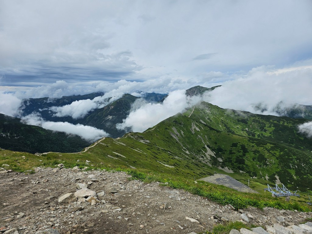
Locate the red trail towards Swinica. When you exit the cable car station, it’s essentially the path right in front of you. After about 10 minutes, you’ll reach a tiny hill on the path – quite rough and rocky, so be careful! There is no official sign there, but there will likely be lots of people, so it’s easy to recognise the right spot. It’s a peak called Beskid, sitting at 2012 metres above sea level. Congratulations, you’ve made it!
By the way. If you’re tempted to just continue walking down that path towards Swinica, don’t! Unless you’ve done your research and know exactly what you’re getting into. Swinica is more of an intermediate mountain, with some challenging bits closer to the peak. Do your research before you go there, and certainly don’t go there ‘on a walk’ if you got to Kasprowy Wierch by the cable car, wearing flip flops, with a toddler in a stroller. It may well be the last thing you do, I’m not exaggerating.

Descent back to Kuznice
From Beskid, we headed back to Kasprowy Wierch. On a sunny day, we would have continued hiking towards Czerwone Wierchy – it’s a picturesque walk along the ridge of the mountains. It is also, unfortunately, quite long – about 2 hours to get to Czerwone Wierchy, and then another 1.5 hours to descend back to Kuznice. On the day of our trip, heavy rainfall was forecasted in the afternoon. It’s not safe to be caught out in heavy rain and thunderstorm high up in the mountains, and there are no shelters on the route. So, we decided to head back to Kuznice.
Once again, we could choose from a few routes. The green trail from Kasprowy Wierch to Kuznice starts from the top of the hill towering above the cable car station, where the real peak of Kasprowy Wierch is. From what I know, that trail runs pretty much along the route of the cable car. I’ve climbed Kasprowy Wierch about 6 or 7 times in my life, but never chose the green trail. The descent is about 3 hours long, no matter which route you choose.
We decided to go back through Murowaniec again, but then chose the yellow trail for the final stretch of our hike. It started to rain about 30 minutes before we reached Kuznice, and we were glad we hadn’t chosen to continue hiking high up in the mountains. The rain picked up later in the day, leading to flooded trails!

Hike summary
Overall, our hike was 17 kilometres long, with 1180 metres elevation gain. It took us 5 hours 55 minutes – I believe I paused my smartwatch during longer breaks, so that was just the moving time. We generally walk quite fast and are lucky to be in good physical shape, and it’s probably fair to assume that an average person would need a bit more time to complete that trip.
Even though I’ve climbed Kasprowy Wierch several times in my life, I always thoroughly enjoy it! The views are stunning, and you get to admire some of the higher mountains in the area. It’s a somewhat challenging hike, but if you’re able to walk uphill for a few hours, I highly recommend it!

Also see: